South Burnett Tourism > Towns > Yarraman
A view of the South Burnett - click to return to the home page of South Burnett Tourism
Yarraman: The Wild Horse Town
Where is Yarraman?
The timber town of Yarraman is located at the junction of the D'Aguilar and New England Highways, approximately 154 kilometres north-west of Brisbane on Highway 17.

It's a terminus of the New England Highway and can be reached by following:
  • the D'Aguilar Highway from Caboolture
  • the Brisbane Valley Highway through Esk
  • the New England Highway from Toowoomba
  • the D'Aguilar Highway from Kingaroy, or
  • the Burnett Highway via Gympie and Goomeri

The town is also a terminus of the Brisbane Valley Heritage Trail (currently under construction)


How big is Yarraman?
Yarraman is the easternmost town in Toowoomba Shire and has a population of around 1,400 residents.

Yarraman has its own hotels, motels, caravan park, convenience and food stores, restaurant and petrol outlets.

Cooyar - located on the New England Highway about 25km to the west of Yarraman - has a hotel, a general store, a petrol outlet and a population of around 250 residents.


What is Yarraman like?
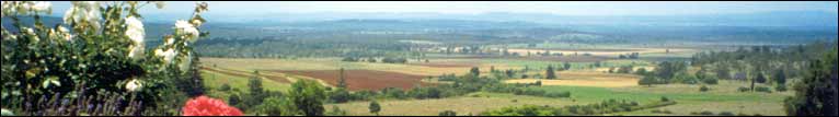
Yarraman is a relaxed country town and most of its CBD is built on the side of a steep hill. It has a low-humidity climate of cool summers and brisk winters.

The town is surrounded by a mixture of commercial hoop pine plantations, State Forests and picturesque South Burnett grazing countryside. The
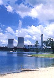
 Tarong 
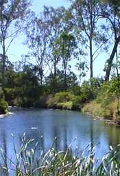
Power Station is located only a short drive to the north and the Ted Pukallus Weir (a popular local fishing hole) is located about 5km south of town.

Yarraman has a rich timber heritage and one of its major industries is the Yarraman Sawmill (the other is the Yarraman Bacon Factory). There are a number of well-marked walking and driving trails through the nearby pine forests and the area is very popular with bushwalkers and naturalists.

One of the town's major tourist attractions is Heritage House, the home of the Yarraman Historical Society. Heritage House was established in 1997 in a former boys' boarding convent - originally as a museum, but now also incorporating extensive art, craft, tapestry and timber displays. It's now being extended as a terminus for the Brisbane Valley Heritage Trail.

Cooyar - a short drive west of Yarraman on the New England Highway - is home to the Palms National Park (one of the smallest national parks in Australia) and the Cooyar suspension bridge. A platypus sanctuary is also being developed there.

Major annual events include the Cooyar Show and Rodeo (held at the Cooyar Showgrounds each February); the Yarraman Horse Ride (held each March); the Yarraman Family Fishing Competition (held each November) and the Yarraman Christmas Carnival (each December).


When was Yarraman established?
The Yarraman area was first settled by Europeans in the mid-1800s when stockmen from the nearby Taromeo and Cooyar Stations used to meet at the location of present-day Yarraman to separate stock. Yarraman itself means "wild horse".

The town itself was founded in the late 1890s when the first logging operations were established in the area, and developed into a major railhead in 1913 when Yarraman became the terminus for the Brisbane Valley line.

Yarraman established its own private electricity company in the 1930s. The plant supplied reliable power to the town and neighbouring areas until the mid-1950s when the State Government took over responsibility for power supplies. The Yarraman Power Company was one of the last private electricity companies in Queensland, and some remains of it can still be seen in the area today.

The Brisbane Valley Line was decommissioned in the 1980s and its loss threw Yarraman into a temporary decline. Today, though, the town draws most of its wealth from timber, agriculture and tourism.


Useful Yarraman information links

Ted Pukallus Weir

Above: The Ted Pukallus Weir and Cooyar Creek are two popular fishing holes near Yarraman. (photo courtesy of Heritage House)

 
Rogers Park near Yarraman

Above: Rogers Park is located close to Yarraman and is surrounded by extensive hoop pine forests. The Park is named in honour of one of Queensland's pioneer foresters, who lived here for many years

 
Tarong Power Station

Above: Tarong Power Station is located a short distance north of Yarraman. The Power Station is closed to visitors, but its information can be viewed at nearby Nanango.

Discover the Magic of the South Burnett

Wine and Food, Great Lakes, Bunya Mounains... Discover The Wonderful Towns Of The South Burnett
You can also find out more about the South Burnett through South Burnett Online and South Burnett Cuisine
Get more information from any of our South Burnett Visitor Information Centres:

NANANGO (07) 4171-0100  ·  KINGAROY (07) 4162-6272  ·  WONDAI (07) 4168-5652  ·  MURGON (07) 4168-3864

Click here to print this South Burnett Tourism page
Click here to email a friend about the South Burnett
Click here to view the South Burnett Tourism site map
Click here to view South Burnett Tourism's site map
Home page  
Click here to return to the South Burnett Tourism home page
Click to return to the top of this South Burnett Tourism page